

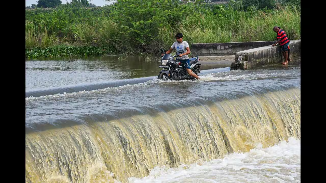
The Ganga water level in Kanpur remained above the warning mark on September 18 despite a gradual decline. The situation continues to affect low-lying areas, with villages in the Katri region facing submerged roads and prolonged disruption to movement and daily life.
Ganga water level remains above warning mark
The Ganga water level in Kanpur has started falling, but the river continues to flow above the warning mark at the Kanpur Barrage, keeping residents in vulnerable areas on alert.
According to the latest Flood Control data reported on September 18, the upstream water level at the Kanpur Barrage was recorded at 114.090 metres. The level had fallen by around 0.21 metre over the previous 24 hours.
The warning mark at the Kanpur Barrage is 114 metres, while the danger level is 115 metres. This means the river was still above the warning threshold, although it remained below the danger mark. The river has stayed above the warning mark for eight consecutive days.
The situation is being closely monitored because even a gradual fall does not immediately remove flood-related risks in areas that are already waterlogged.
Katri villages continue to face floodwater
The biggest local impact is being reported in the Katri area along the Ganga. Several villages and their approach routes remain submerged, with water reportedly reaching two to three feet in some locations.
For residents of riverside villages, the problem is not limited to water entering homes or agricultural land. Submerged approach roads can cut off access to nearby markets, schools, healthcare facilities and public transport.
The continuing waterlogging also makes it difficult for residents to move between villages and reach essential services. When roads remain underwater for several days, even routine activities such as purchasing groceries, accessing medicines or travelling for work can become difficult.
Authorities are continuing to monitor affected areas as the river level gradually recedes. However, the situation on the ground can remain difficult even after the main river begins falling because standing floodwater takes time to drain.
Shuklaganj water level remains below warning mark
The situation is different at Shuklaganj, another important monitoring point near Kanpur.
The Ganga water level at Shuklaganj was recorded at 112.550 metres, which is below its warning mark of 113 metres. Its danger level is 114 metres.
The difference between the readings at the Kanpur Barrage and Shuklaganj shows why flood monitoring needs to be location-specific. Water levels can vary between monitoring points depending on river flow, barrage operations and local conditions.
Earlier in September, rising water levels had already caused waterlogging across several parts of the Kanpur region. Reports from September 11 said around 25 localities, including Makdikheda, had been dealing with waterlogging for nearly 12 days, with residents also facing problems related to stagnant water, dirt and mosquitoes.
The current decline in the river level may offer some relief, but areas already affected by standing water may take longer to recover.
Why the warning mark matters
A river crossing its warning mark does not automatically mean that a major flood is occurring across an entire city.
The warning mark is an important threshold used by authorities to increase vigilance and monitor the possibility of further flooding. The danger mark is higher and indicates a more serious flood risk at the monitoring location.
At the Kanpur Barrage, the latest reported level of 114.090 metres is only slightly above the 114-metre warning level and remains below the 115-metre danger mark.
This distinction is important when interpreting flood updates. A river can remain above its warning mark while authorities continue to monitor whether the level is rising or falling.
In Kanpur’s case, the latest trend is downward. However, the continued presence of floodwater in low-lying and riverside areas means that local disruption remains a concern.
Upstream releases remain important for Kanpur
Water flowing through the Ganga at Kanpur is influenced by conditions upstream as well as rainfall and local inflows.
On September 18, the Haridwar Barrage was reported to have released 70,705 cusecs of water, while the Narora Barrage released 58,389 cusecs. Such releases are among the factors authorities monitor when assessing downstream river conditions.
The Kanpur Barrage itself recorded a discharge of 5,44,373 cusecs in the latest assessment reported by The Times of India.
This is why water-level monitoring does not stop when rainfall decreases. Officials need to track inflows, upstream releases and the rate at which water moves downstream.
For people living close to the river, these changes can affect how quickly water levels rise or recede.
Flooding can affect agriculture and local livelihoods
The Ganga’s high water level can also create problems for agricultural communities around Kanpur and neighbouring areas.
When floodwater enters farmland, standing crops can be damaged or destroyed depending on the duration of inundation and the type of crop being grown. Even when fields are not completely submerged, prolonged waterlogging can affect crop health and delay agricultural operations.
Farmers may also face difficulty reaching fields when approach roads remain underwater.
The impact can extend to livestock owners and small businesses in affected villages. Transport disruptions can make it harder to move agricultural produce, purchase animal feed or reach local markets.
The economic impact therefore depends not only on the river’s peak level but also on how long surrounding areas remain waterlogged.
Health and sanitation concerns may persist
Flooding creates another challenge after the immediate water-level threat: sanitation.
Standing water can remain around homes, roads and public spaces even after the river begins to recede. This can contribute to unhygienic conditions and increase mosquito breeding.
Earlier reports from Kanpur’s waterlogged localities highlighted concerns about dirt and mosquitoes as residents dealt with prolonged waterlogging.
Residents in affected areas may therefore continue to face health and sanitation challenges even as the Ganga’s level falls.
Local authorities generally need to focus not only on river monitoring but also on drainage, sanitation, safe drinking water and access to medical services in affected communities.
What residents should watch next
The immediate focus will be whether the Ganga continues its downward trend at the Kanpur Barrage and whether water recedes from the Katri region and other low-lying locations.
The latest data provides some indication of improvement because the river level declined by about 0.21 metre in 24 hours. However, it remained above the warning mark for the eighth consecutive day, meaning monitoring remains necessary.
Residents in flood-prone areas should continue following local administration advisories, particularly regarding movement near riverbanks and flooded roads.
For people whose villages remain surrounded by water, the practical issue is access. Even if the river level falls below the warning mark, roads, fields and low-lying settlements may require additional time to dry out and return to normal.
The situation in Kanpur therefore remains one of gradual improvement rather than an immediate end to flood-related disruption.
Key Takeaways
- The Ganga at Kanpur Barrage was recorded at 114.090 metres on September 18, above the 114-metre warning mark.
- The river level declined by around 0.21 metre in the previous 24 hours but remained above the warning threshold for the eighth consecutive day.
- Villages in the Katri area continue to face submerged approach routes and waterlogging of around two to three feet in some locations.
- Shuklaganj recorded 112.550 metres, below its 113-metre warning mark, showing differences between monitoring locations.
FAQs
What is the current Ganga water level in Kanpur?
The Ganga water level at the Kanpur Barrage was recorded at 114.090 metres in the latest report dated September 18, 2026. This was above the warning mark of 114 metres but below the danger mark of 115 metres.
Is the Ganga water level rising or falling in Kanpur?
The latest trend is downward. The water level at the Kanpur Barrage declined by approximately 0.21 metre over 24 hours. However, the river remained above the warning mark for the eighth consecutive day.
Which areas are facing the biggest local impact?
The Katri area along the Ganga continues to face serious disruption, with several villages and approach routes submerged. Some locations have reported two to three feet of floodwater.
Is Kanpur Ganga water level above the danger mark?
No. The latest reported level of 114.090 metres at the Kanpur Barrage was above the 114-metre warning mark but below the 115-metre danger mark.








Leave a comment