

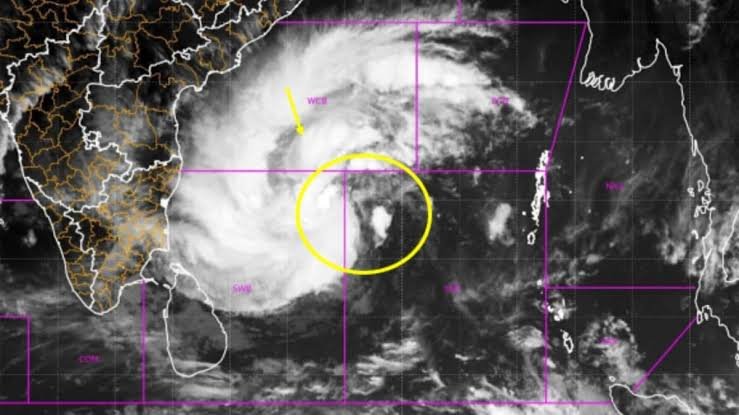
Cyclone Akvan has intensified into a severe cyclonic storm over the Bay of Bengal, prompting weather warnings for coastal Andhra Pradesh, Yanam and parts of Odisha. The India Meteorological Department (IMD) has forecast heavy rainfall, strong winds and rough sea conditions ahead of its expected landfall on November 20, 2026.
Article classification: Time-sensitive news explainer
Latest official update checked: November 18, 2026
Cyclone Akvan Intensifies Over the Bay of Bengal
Cyclone Akvan has become a major weather concern for India’s eastern coastline as it continues moving north-northwestwards over the Bay of Bengal. According to the India Meteorological Department’s November 18 morning bulletin, the system intensified into a severe cyclonic storm.
At 5:30 am IST on November 18, the cyclone was centred near latitude 12.7°N and longitude 85.5°E. It was located approximately 580 km east of Chennai, 610 km southeast of Machilipatnam in Andhra Pradesh and 730 km south of Gopalpur in Odisha.
The weather system had been moving slowly, at around 3 kmph during the preceding six hours. Its projected movement has placed the Andhra Pradesh and Yanam coastline under close observation.
The IMD has forecast that Cyclone Akvan will continue moving north-northwestwards before approaching the Andhra Pradesh coast. Residents in coastal districts have been advised to follow official weather updates and take precautionary measures.
Cyclone Akvan Landfall Forecast: What Happens on November 20?
According to the latest available IMD bulletin issued on November 18 morning, Cyclone Akvan is likely to cross the Andhra Pradesh and Yanam coasts between Nellore and Visakhapatnam around noon on November 20.
The morning forecast estimated maximum sustained wind speeds of 100–110 kmph, with gusts reaching 120 kmph.
This is an important update because an earlier November 17 forecast had projected the possibility of the system intensifying into a very severe cyclonic storm, with higher wind speeds of 120–130 kmph and gusts up to 145 kmph.
The updated November 18 forecast classified the expected landfall intensity as a severe cyclonic storm. Cyclone forecasts can change as the system develops, making the latest official bulletin more relevant than earlier projections.
Residents should therefore avoid relying on older forecasts shared through social media.
Heavy Rainfall Warning for Andhra Pradesh and Odisha
Rainfall is expected to be one of the major concerns associated with Cyclone Akvan. The IMD has forecast widespread rainfall across coastal Andhra Pradesh and Yanam between November 19 and 21.
According to its November 18 morning weather bulletin, the following rainfall conditions are expected:
- November 18: Heavy rainfall at isolated places in coastal Andhra Pradesh and south coastal Odisha.
- November 19: Heavy to very heavy rainfall at several places in coastal Andhra Pradesh, with isolated extremely heavy rainfall possible. South coastal Odisha may also receive heavy to very heavy rainfall.
- November 20: Heavy to very heavy rainfall is likely to continue across coastal Andhra Pradesh and Odisha.
- November 21: Rainfall may gradually decrease over Andhra Pradesh, while Odisha could continue experiencing heavy rainfall at isolated locations.
The IMD has also warned of thunderstorms, lightning and strong winds. Coastal Andhra Pradesh and Yanam could experience thundersqualls, with wind speeds potentially reaching 100–110 kmph and gusts up to 120 kmph on November 19 and 20, according to the morning forecast.
Odisha is also expected to experience thunderstorms and gusty winds during the cyclone’s approach.
Which Districts Could Be Affected by Cyclone Akvan?
Coastal districts are likely to face the greatest weather-related risks because of their proximity to the projected cyclone track.
In Andhra Pradesh, districts that need close monitoring include:
- Nellore
- Prakasam
- Bapatla
- Krishna
- West Godavari
- Konaseema
- Kakinada
- Visakhapatnam
The IMD’s national cyclone bulletin has specifically identified several low-lying coastal districts where storm surge could create additional risks.
In Odisha, southern coastal and adjoining districts are expected to experience rainfall and strong winds. Ganjam, Gajapati, Puri, Rayagada, Koraput and Malkangiri are among the areas requiring attention based on the reported state-level warnings.
The impact will not necessarily be the same across every district. Rainfall intensity, wind speeds and local flooding risks can vary depending on the cyclone’s final movement and distance from the coastline.
People living in low-lying settlements, coastal villages and areas vulnerable to flooding should pay particular attention to instructions issued by local administrations.
Storm Surge and Rough Sea Conditions: Why Coastal Residents Should Be Careful
Apart from rainfall and strong winds, storm surge is another important concern during a tropical cyclone.
Storm surge refers to an abnormal rise in seawater caused primarily by strong cyclone winds pushing water towards the coastline. When it coincides with high tides, seawater can enter low-lying coastal settlements and cause flooding.
The IMD’s November 18 cyclone bulletin warned that a storm surge of approximately 0.4–1.2 metres above astronomical tide could inundate low-lying areas of Andhra Pradesh during landfall.
The districts identified in the warning include Prakasam, Bapatla, Krishna, West Godavari, Konaseema, Kakinada and Visakhapatnam.
Sea conditions are also expected to deteriorate. The waters along and off the Andhra Pradesh coast could become extremely rough as the cyclone approaches. Odisha’s coastline is also expected to experience increasingly rough seas.
Fishermen have been advised not to venture into the affected areas of the Bay of Bengal during the warning period. People should avoid beaches, fishing harbours and exposed coastal locations until authorities declare conditions safe.
What Are Authorities Doing Before Cyclone Akvan’s Landfall?
Preparing communities before a cyclone reaches land is essential for reducing casualties and limiting damage.
According to an India Today report published on November 17, Andhra Pradesh Chief Minister N. Chandrababu Naidu directed officials to deploy national and state disaster response teams ahead of the expected landfall.
The administration was also asked to keep electricity restoration teams ready in case strong winds damage power infrastructure.
In Odisha, district administrations have been instructed to focus on vulnerable settlements, particularly low-lying areas and hill communities that could face flooding or landslides.
These preparations are important because heavy rainfall can create problems even in locations that do not experience the strongest cyclone winds.
For residents, official evacuation instructions should be treated seriously. Local authorities may identify temporary shelters and arrange transportation for people living in vulnerable areas.
People should also avoid spreading unverified messages about evacuation orders, school closures or cyclone intensity.
Cyclone Safety: Precautions Residents Should Take
With Cyclone Akvan expected to approach the coastline on November 20, residents in potentially affected areas should complete basic preparations before weather conditions deteriorate.
Here are some important precautions:
1. Follow official weather alerts: Check regular updates from the IMD, state disaster management authorities and district administrations. Do not depend on old weather forecasts circulating on WhatsApp or social media.
2. Keep emergency supplies ready: Store drinking water, dry food, essential medicines, a torch, batteries, a power bank and important documents in a waterproof bag.
3. Avoid unnecessary travel: Strong winds, heavy rainfall and waterlogging can make roads dangerous. Postpone non-essential journeys during severe weather conditions.
4. Stay away from coastal areas: Avoid beaches, fishing activities, harbours and other exposed locations. Fishermen should follow official restrictions on entering the sea.
5. Secure homes and outdoor objects: Bring loose outdoor furniture, temporary structures and other movable objects indoors. Stay away from trees, electric poles and damaged power lines.
6. Follow evacuation instructions: People living in vulnerable coastal settlements should move to designated shelters whenever instructed by local authorities.
Cyclones can change direction and intensity. Residents should remain prepared even if their immediate area does not initially experience severe weather.
How Could Cyclone Akvan Affect Daily Life and Local Businesses?
The impact of Cyclone Akvan may extend beyond coastal villages and fishing communities.
Heavy rainfall and strong winds can disrupt transportation, electricity supply, schools, agricultural activities and local businesses.
For small traders, street vendors and shop owners in coastal towns, waterlogging and temporary closures could affect daily income. Markets dependent on agricultural produce may also experience supply disruptions if transport routes are affected.
Farmers in vulnerable areas should monitor local agricultural advisories, particularly if their crops are approaching harvest. Excessive rainfall and strong winds can damage standing crops and affect storage facilities.
Fishing communities may face temporary income losses because of restrictions on fishing activities. Local fish markets, seafood businesses and transport operators could also experience disruptions.
For residents in Tier-2 and Tier-3 cities, timely information about road conditions, electricity interruptions, public transport and school operations will be particularly important.
However, these are potential impacts rather than confirmed disruptions. Actual consequences will depend on the cyclone’s final track, rainfall distribution and local preparedness.
What Residents Should Watch Before November 20
The next 48 hours will be important for understanding Cyclone Akvan’s movement and potential impact.
The IMD’s November 18 morning bulletin provides the latest official assessment used in this article. However, the cyclone’s projected intensity and wind estimates have changed between successive bulletins.
Residents should particularly monitor:
- Changes in the cyclone’s projected landfall location.
- Updates to wind speed and rainfall warnings.
- District-level evacuation announcements.
- School, college and public transport advisories.
- Fishing restrictions and coastal safety instructions.
The situation should be assessed using fresh IMD bulletins rather than treating any single forecast as final.
Key Takeaways
- Cyclone Akvan intensified into a severe cyclonic storm over the Bay of Bengal on November 18, 2026.
- The IMD has forecast landfall along the Andhra Pradesh and Yanam coast between Nellore and Visakhapatnam around November 20.
- Coastal Andhra Pradesh and southern Odisha are expected to experience heavy rainfall, strong winds and rough sea conditions.
- Residents should follow IMD updates, avoid coastal activities and comply with evacuation instructions issued by local authorities.
Frequently Asked Questions (FAQs)
1. When is Cyclone Akvan expected to make landfall in India?
According to the IMD’s November 18 morning bulletin, Cyclone Akvan is likely to cross the Andhra Pradesh and Yanam coasts between Nellore and Visakhapatnam around noon on November 20, 2026.
2. Which states are likely to be affected by Cyclone Akvan?
Andhra Pradesh and Odisha are expected to experience significant weather impacts. Yanam, Tamil Nadu and Telangana may also experience rainfall and strong winds associated with the weather system.
3. What wind speed is expected during Cyclone Akvan?
The IMD’s November 18 morning bulletin projected maximum sustained winds of 100–110 kmph, gusting to 120 kmph, around landfall. Its wind warning also indicated the possibility of winds reaching 120–130 kmph, with gusts up to 145 kmph near the Andhra Pradesh and Yanam coasts. Residents should check subsequent bulletins for revised estimates.
4. Should fishermen avoid entering the sea during Cyclone Akvan?
Yes. The IMD has issued restrictions advising fishermen not to venture into the affected areas of the Bay of Bengal. They should resume fishing only after official authorities withdraw the warnings and declare conditions safe.












Leave a comment