

District administrations across India are increasingly adopting technology to improve disaster preparedness, emergency response, and relief operations. From AI-powered weather forecasting to drone surveillance and GIS mapping, digital tools are helping authorities respond faster, coordinate better, and reduce the impact of natural disasters.
How District Administrations Are Using Technology for Disaster Response
Technology for disaster response has become a crucial part of India’s disaster management strategy. As floods, cyclones, landslides, heatwaves, and other extreme weather events become more frequent, district administrations are relying on digital solutions to improve preparedness and emergency response. The shift is driven by initiatives from the National Disaster Management Authority (NDMA), the India Meteorological Department (IMD), state disaster management authorities, and local governments.
Rather than replacing traditional emergency systems, technology is helping district officials make faster decisions, communicate more effectively, and deploy resources where they are needed most.
Early Warning Systems Are Improving Preparedness
One of the biggest improvements in disaster response is the availability of advanced early warning systems.
The India Meteorological Department now provides more accurate weather forecasts using satellite observations, Dopservation radars, and numerical weather prediction models. These forecasts are shared with district administrations through dedicated digital platforms.
Many districts receive alerts several hours or even days before heavy rainfall, cyclones, thunderstorms, or heatwaves. Officials then coordinate with police departments, municipal bodies, health services, and local disaster response teams to begin preventive measures.
Mobile alerts, SMS notifications, television broadcasts, radio announcements, and social media updates are also used to warn residents about approaching hazards.
These early warnings have significantly improved evacuation planning and reduced casualties during several recent cyclones along India’s eastern and western coasts.
GIS Mapping Helps Officials Identify High-Risk Areas
Geographic Information System (GIS) technology has become an essential planning tool for district administrations.
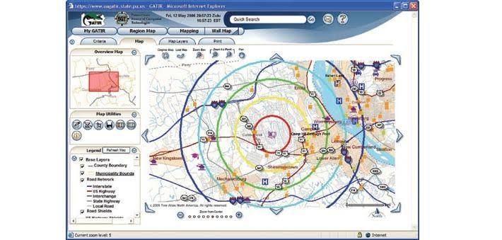
GIS maps combine information about rivers, roads, villages, schools, hospitals, bridges, drainage systems, and population density into a single digital platform. During floods or landslides, officials can quickly identify vulnerable areas and prioritize rescue operations.
Several districts regularly update hazard maps that highlight flood-prone zones, landslide-prone regions, coastal risk areas, and urban waterlogging hotspots.
These maps also help authorities decide where temporary relief camps should be established and which evacuation routes remain accessible during emergencies.
GIS-based planning has become especially valuable in states such as Assam, Kerala, Maharashtra, Odisha, Uttarakhand, and Himachal Pradesh, where natural disasters occur frequently.
Drones Are Transforming Damage Assessment
Drone technology is now widely used by many district administrations after disasters.
Following floods or landslides, drones capture high-resolution aerial images of affected villages, damaged roads, collapsed bridges, and blocked river channels. These visuals help officials assess the scale of damage without sending personnel into unsafe areas.
Drone surveys also support relief planning by identifying isolated communities that require immediate assistance.
In agricultural regions, drones have been used to estimate crop damage following floods, hailstorms, or cyclones. This information supports compensation assessments and speeds up administrative processes.
As drone regulations have evolved, their role in disaster management has expanded across multiple states.
Digital Communication Enables Faster Coordination
Effective disaster response depends on communication between different departments.
District administrations increasingly use integrated digital communication platforms to coordinate with police, fire services, ambulance networks, electricity departments, municipal corporations, and disaster response forces.
Video conferencing systems allow senior officials to monitor field operations in real time, while mobile applications enable local officers to submit photographs, location updates, and situation reports directly from affected areas.
Many control rooms also use digital dashboards that display weather forecasts, rainfall levels, river water data, road closures, and emergency service deployment on a single screen.
This centralized view helps district collectors make quicker operational decisions.
Artificial Intelligence and Data Analytics Support Better Decision-Making
Artificial intelligence is gradually becoming part of disaster management planning.
AI models analyze weather patterns, rainfall intensity, river levels, satellite imagery, and historical disaster data to identify areas that may face higher risks.
Although AI does not replace human decision-making, it provides additional insights that help authorities prepare resources in advance.
Data analytics also supports better allocation of rescue teams, emergency shelters, food supplies, and medical assistance based on population estimates and projected impact zones.
As more government departments digitize records, predictive analytics is expected to play a larger role in future disaster planning.
Challenges Remain Despite Technological Progress
While technology has strengthened disaster response, several challenges continue to exist.
Internet connectivity remains unreliable in some remote and hilly regions. Power outages during severe weather can disrupt communication systems, making backup infrastructure essential.
Not every district has equal access to advanced drones, GIS specialists, or real-time monitoring equipment. Capacity building, staff training, and regular technology upgrades remain important priorities.
Public awareness is equally critical. Even the best warning systems are effective only when people receive alerts, understand the risks, and follow official evacuation instructions.
India’s Digital Disaster Management Is Evolving
India’s district administrations are steadily moving toward technology-driven disaster management. The combination of early warning systems, GIS mapping, drones, digital communication platforms, and data analytics is improving preparedness across many regions.
As climate-related disasters become more frequent, investments in digital infrastructure, better coordination, and community awareness will remain essential. While technology cannot prevent natural disasters, it is helping authorities reduce risks, improve response times, and protect lives more effectively.
Takeaways
- Early warning systems enable district administrations to prepare before disasters strike.
- GIS mapping and drone technology improve rescue planning and damage assessment.
- Digital communication platforms strengthen coordination among emergency agencies.
- AI and data analytics are emerging tools that support faster and more informed decision-making.
FAQ
Q1. What technologies are commonly used by district administrations during disasters?
District administrations use early warning systems, GIS mapping, drones, satellite imagery, digital communication platforms, mobile alert systems, and increasingly AI-based data analysis.
Q2. How do drones help during disaster response?
Drones provide aerial images of affected areas, assess infrastructure damage, identify stranded communities, and support relief planning without exposing rescue personnel to unnecessary risks.
Q3. Why is GIS important in disaster management?
GIS helps authorities map vulnerable locations, identify evacuation routes, locate relief camps, and allocate emergency resources more efficiently.
Q4. Can artificial intelligence predict natural disasters?
AI cannot predict all disasters, but it can analyze weather patterns, historical data, and environmental conditions to improve risk assessment and support disaster preparedness.










Leave a comment